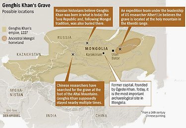
Unfortunately not everyone agrees on the probable location of the great khan’s tomb. (click on picture for larger image)
Motherboard has one of those stories that fires the imagination. We just have to hope they’re working on the right location.
Genghis Khan really, really didn’t want anyone to know where he was buried. The soldiers escorting his body to its final resting place killed everyone they passed, killed the people who built the tomb, and then were killed themselves. Some say Mongol troops grazed herds of horses over the site or even diverted a river over it to keep it hidden. The area where many suspect Genghis Khan is buried is one of Mongolia’s most sacred heritage sites—it’s name, Ikh Khorig, actually translates to “The Great Taboo.†For 800 years—until 1989—archeologists weren’t allowed in, and even then the first expedition was met with public protest.
“Mongolians detest any attempt to touch graves, or even wander around graveyards,†Mongolia Today explains. “According to ancient tradition, burial spots are forbidden areas in which no one is allowed.â€
Still, and perhaps for that very reason, this region is really interesting for archeologists. That first three-year expedition identified 1,380 underground cavities that could be the graveyards or tombs of Mongolian nobles, potentially even predating Genghis Khan.
Albert Yu-Min Lin, from the Center for Interdisciplinary Science in Art, Architecture, and Archaeology at the University of California, San Diego, devised a way to hunt for Genghis Khan’s tomb without touching or toppling anything: Have anyone who’s interested in doing so tag potential sites of investigation from the comfort of their own homes, on images taken from the respectful distance of satellite orbit.
“Explorers†were welcome to map rivers and roads, and flag modern structures, as well as potentially ancient structures on thousands of ultra-high resolution satellite images of the region. There was a lot of ground to cover—6,000 square kilometers, but there were also a lot of volunteers. The system was launched in June 2010, and in just its first 90 days, 5,838 people had contributed more than 1.2 million tags. By the end of the year, over 10,000 participants had generated 2.3 million tags—contributing a total of 30,000 hours of human visual analytics to the images, according to the study’s initial results, just published in the journal PLOS One.
The results have given future explorers plenty to chew on, too. “Of the top 100 accessible locations identified by the crowd,†the study states, “55 potential archaeological anomalies were verified by the field team, ranging from bronze age to Mongol period in origin.â€
Read the whole thing.


Please Leave a Comment!