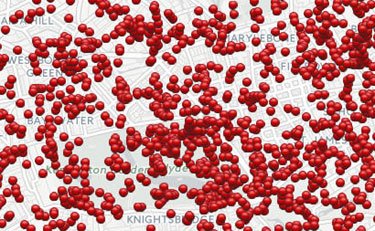
Bomb Sight is an interactive map project of the University of Portsmouth, allowing to viewer to see where each of more than 30,000 German bombs fell on London between 7 October 1940, and 6 June 1941, killing 30,000 people.

|
08 Aug 2016
Mapping The BlitzLondon, The Blitz, WWII
Bomb Sight is an interactive map project of the University of Portsmouth, allowing to viewer to see where each of more than 30,000 German bombs fell on London between 7 October 1940, and 6 June 1941, killing 30,000 people.
Welcome to
NEVER YET MELTED
Another Right-Wing Web Aggregator and Purveyor of Unpopular Opinions
 David Zincavage contact: jdz@usa.net blog advertising is good for General Bullmoose and good for the USA. 


Feeds
|
GoneWithTheWind
Interesting. Someone should make a more relevant system to map out the murders, rapes, and other attacks by Muslims immigrants and asylum seekers. This would be especially useful since the media and government conspire to keep this secret. Maybe the scope of the problem would then become obvious and the citizens would demand change.
Steve Gregg
What’s interesting to me as a former navigator/WSO in USAF F-4Es is how few people that bombs kill. That one person killed per bomb metric from the Blitz seems to be some sort of general rule of thumb. The carpet bombing of Japan likewise produced a low yield of killed per bomb. While it seems obvious that a bomb dropped in a group of people should kill them all, most bombs drop harmlessly to human life. While I was always struck by how big and violent a bomb explosion was when I was looking down into it, I was also struck by what a tiny pin prick it was on the Earth as I flew away.
Ron E.
As soon as I saw the title and the first presentation of bomb distribution in and near London, my immediate thought, like those of others I am sure, was of Pynchon’s Gravity’s Rainbow. Here the author describes a wide range of statistical efforts to determine future V-2 strikes. This even leads to one character trying to link the location of Lt. T. Slothrop’s sexual encounter with imminent targets.
Please Leave a Comment!