Just How Fat Is That Bear?
Alaska, Brown Bears, Lidar, Measure
High Country News reports on a clever method of finding out.
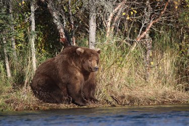
Brown bears are fattening up for winter hibernation in Alaska’s Katmai National Park and Preserve. And starting today, thousands of viewers from around the world will tune in for Fat Bear Week to watch the bears gobble fish from the Brooks River, estimate how well they’re packing on the pounds, and then vote for the portliest in a single elimination bracket.
But just how fat are those fat bears? A winner will be crowned Oct. 5, but webcam viewers — almost 650,000 cast votes last year — and actual visitors — 15,000 came to Brooks Falls to see the bears in 2019 — are just guesstimating. But there’s hope for achieving greater accuracy: GIS specialist Joel Cusick is pioneering a new technique for calculating the bears’ weight that has broader implications for noninvasive wildlife research.
The idea came to Cusick, who works for the National Park Service in Alaska, in 2018, while he was working on mapping and surveying at Katmai. A terrestrial lidar scanner, which uses lasers to determine distance and other measurements, was on hand to measure buildings. That’s the device traditional civil engineers use, but when Cusick wandered down to Brooks Falls and stood on a viewing platform 300 feet away from the bears, inspiration hit. He thought: Why not use the scanner to measure a bear’s surface volume instead?
“I got a laser return from the butt of Otis, one of the more famous brown bears up there,” Cusick said. “I thought, ‘Wow, this just might work.’”
Lidar, which stands for “light detection and ranging,” emits beams of light to measure three-dimensional objects or areas. When light waves hit an object, they bounce off and return to the sensor. Computers then use the speed of light to calculate the distance between the sensor and all the points. That figure is then processed using software that can model a three-dimensional object. Scanners have become standard technology that is deployed from the ground, the sky and satellites to measure vegetation growth. Now, they’re being used to measure bears’ length, height and girth.