Category Archive 'Mesolithic'
10 Dec 2024

Magdalenian 14,000 years old
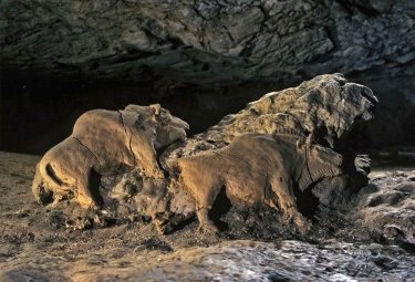
Cave Bison of Tuc d’Audoubert Sculptures of the Ice Age
These bison were prominently positioned at the centre of a small, difficult to reach chamber deep in the cave system of Tuc d’Audoubert. Made from unbaked clay, the composition depicts the larger bull positioned behind a cow. Their bodies were moulded by hand and still show finger marks. The details of the heads and necks were carved or incised using tools. The tail of the cow, now broken off, was raised ready for mating.
Le Tuc d’Audoubert cave, Ariège, France
01 Feb 2020


Science Magazine:
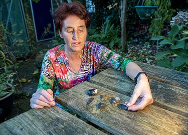
On a clear, windy autumn afternoon last October, Willy van Wingerden spent a few free hours before work walking by the sea not far from the Dutch town of Monster. Here, in 2013, the cheerful nurse found her first woolly mammoth tooth. She has since plucked more than 500 ancient artifacts from the broad, windswept beach known as the Zandmotor, or “sand engine.†She has found Neanderthal tools made of river cobbles, bone fishhooks, and human remains thousands of years old. Once, she plucked a tar-covered Neanderthal tool from the water’s edge, earning a co-author credit in the Proceedings of the National Academy of Sciences (PNAS) a few months ago.
“Sun, wind, rain, snow—I’m here 5 or 6 days a week,†she says. “I find something every day, almost.â€
Van Wingerden’s favorite beachcombing spot is no ordinary stretch of sand. Nearly half a kilometer wide, the beach is made of material dredged from the sea bottom 13 kilometers offshore and dumped on the existing beach in 2012. It’s a €70 million experimental coastal protection measure, its sands designed to spread over time to shield the Dutch coast from sea-level rise. And the endeavor has made 21 million cubic meters of Stone Age soil accessible to archaeologists.
That soil preserves traces of a lost world. During the last ice age, sea levels were 70 meters lower, and what is now the North Sea between Great Britain and the Netherlands was a rich lowland, home to modern humans, Neanderthals, and even earlier hominins. It all disappeared when glaciers melted and sea level rose about 8500 years ago.
RTWT
HT: Bird Dog.
11 Jul 2008


Submerged in recent times, there was in the Mesolithic period a land bridge connecting Britain with the continent. Fishermen working the Dogger Banks have pulled up prehistoric human artifacts in their nets, and archaeologists consequently named the sunken landscape once thick with human settlement Doggerland. Efforts at mapping Doggerland are currently underway.
Nature News:
Doggerland is key to understanding the Mesolithic in northern Europe,†says Vince Gaffney, a landscape archaeologist at the University of Birmingham, UK.
Along with his colleagues Simon Fitch and the late Ken Thomson, Gaffney established the mapping project to outline the terrain of Doggerland, named after the sandbank and shipping hazard of the Dogger Bank (see ‘Mesolithic sites around the North Sea’). They managed to borrow seismic survey data, which outline sediment layers below the seabed, from the Norwegian oil company Petroleum Geo-Services. The researchers then put their powerful computers to work to reconstruct Doggerland in three dimensions.
In a pilot project beginning in 2002, the researchers reconstructed 6,000 square metres of the ancient landscape — slightly larger than a football field. There, about 10 metres beneath the modern seabed, they discovered the course of a major ancient river, almost as big as today’s Rhine. They named it the Shotton River, after Birmingham geologist Fred Shotton who, among other things, was dropped behind enemy lines to map the geology of the Normandy beaches before the D-Day landings. Now confident that the reconstruction would work, the researchers expanded the project. The result is a 23,000-square-kilometre map of a part of Doggerland — an area the size of Wales — that they hope eventually to extend northward as well as eastward, towards the Netherlands.
Your are browsing
the Archives of Never Yet Melted in the 'Mesolithic' Category.
/div>

Feeds
|


