The first time James Terry heard the legend of Makin Island’s three boulders was in 2012. Romano Reo, a retired chief surveyor from the Kiribati Lands and Survey Department, emailed him and relayed the story of a fabled king who once lived on an island that is now part of the Republic of Kiribati in the central Pacific Ocean. In the story, people on the nearby Makin Island brought the king a gift of fruit. But the fruit was rotten, and the king, enraged by the affront, sent three giant waves to punish the Makin Islanders. Each wave carried a huge rock toward the shore. As the deluge crashed down, the terrified islanders begged for forgiveness. The king relented, stopping the third wave just in time.
The story grabbed Terry because, as a geoscientist at Zayed University in the United Arab Emirates, he had a thing about offshore boulders. He wondered if the story was, in fact, more than a story. It was possible that the tale about the angry king, passed down by the island’s Indigenous Micronesians, might be a geomyth—a legend that encodes true information about an area’s geological past.
And so, in June 2018, Terry and fellow researchers went to Makin Island to find out. They introduced themselves to the locals, making a traditional offering of tobacco to their ancestors. With their guidance, the researchers were led to Makin’s southern shores. There, standing proudly and almost entirely out of the water during low tide, were two massive rocks.
“They’re just sitting all alone, these isolated, huge boulders,” says Terry. Each of the rocks has a name. Arranged in a line, roughly east to west, are Tokia, a boulder 22 meters in circumference, and Rebua, slightly smaller at 18.5 meters. The third stone, Kamatoa, is the largest. Roughly 39 meters in circumference—broader than a school bus is long—Kamatoa is always underwater. It is the king’s mercy.
While on the trip, they unexpectedly met Tobeia Kabobouea, a man in his 60s who holds the position of the Wiin te Maneaba, or traditional storyteller. The man is a “living archive,” as Terry and his colleagues write in a recent paper. Noticing the scientists’ interest in the stones, Kabobouea offered to recite a story.
He proceeded to narrate a different tale from the one Terry had heard years earlier by email. The Wiin te Maneaba told the story of a Makin Island man who was cheated by his community. His neighbors on a nearby island had an ability to summon and hunt dolphins, but gave the Makin Island man only the internal organs—never the tastier meat. Out of anger, the man called three waves, each carrying a huge stone, and sent them hurtling toward the villagers. Eventually, he felt remorse and halted the final and most destructive wave.
That’s two distinct—yet strikingly similar—accounts of gigantic waves bearing Tokia, Rebua, and Kamatoa to their present resting places. Read the rest of this entry »
An 8.5-million-pound rock that fell from a ridge onto a Colorado highway will be turned into a landmark, Gov. Jared Polis announced. The rock will remain on Highway 145 between Cortez and Telluride, and the road will be rebuilt around it.
The boulder, which is the size of a two-story building, tumbled from a cliff 2,000 feet above the roadway, CDOT officials said.
Another smaller boulder also smashed into the road, carving a deep trench across the highway. The smaller rock has been blasted, and its fragments were carried away.
The new landmark boulder will be dubbed “Memorial Rock,” in honor of Memorial Day Weekend, when it fell, officials said.
Leaving the boulder where it fell will save taxpayers around $200,000 in blasting and cleanup costs, Polis said.
The Polis administration was filing federal paperwork for the landmark designation.
The official history of Earth has a new chapter – and we are in it.
Geologists have classified the last 4,200 years as being a distinct age in the story of our planet.
They are calling it the Meghalayan Age, the onset of which was marked by a mega-drought that crushed a number of civilisations worldwide.
The International Chronostratigraphic Chart, the famous diagram depicting the timeline for Earth’s history (seen on many classroom walls) will be updated.
Rattlesnake Ridge is a large hillside located above the I-82 highway to the south of the town of Yakima in Washington State, NW USA. The Google Earth image below shows the location of the site (at 46.524, -120.467), taken in May 2017. The image is looking towards the east – note the large active quarry on the south side of the ridge, and other signs of earlier (and smaller scale) excavation on the slope. Note also the proximity of the slope to I-82.
The latest reports suggest that the crack is widening at a rate of about 30 cm per week at present. Interestingly KIMA TV reports that the expectation is that the slope will self-stabilise:
Senior Emergency Planner Horace Ward said they have not determined a cause yet and said it’s just nature. Ward said the ridge is being monitored and they think the slide will stop itself.
“It could continue to move slowly enough to where it kind of just keeps spilling a little bit of material into the quarry until it creates a toe for itself to stop and stabilize the hillside,†he said.
The implication of this is that it is a rotational slip. However, the tension crack has quite a complex structure, with some evidence of the development of a graben structure.
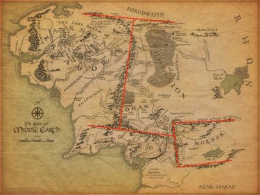
Alex Acks is a geologist who thinks J.R. Tolkien, where geology is concerned, is an excellent scholar of linguistics.
I’m good with the mountain ranges on the west coast of the map. I can pretend that Eriador is like the California of Middle-earth, and it’s a nice active margin—I will just ignore that my housemate, who unlike me has completed the Silmarillion slog, has disabused me of that notion. And I can buy the placement of the Misty Mountains, again as a continent-continent collision, perhaps, even if there should be a lot more shenanigans going on then, in terms of elevation. But when you throw in the near perpendicular north and south mountain ranges? Why are there corners? Mountains don’t do corners.
And Mordor? Oh, I don’t even want to talk about Mordor.
Tectonic plates don’t tend to collide at neat right angles, let alone in some configuration as to create a nearly perfect box of mountains in the middle of a continent. I’ve heard the reasoning before that suggests Sauron has made those mountains somehow, and I suppose right angles are a metaphor for the evil march of progress, but I don’t recall that being in the books I read. And ultimately, this feels a lot like defending the cake in the song MacArthur Park as a metaphor—okay fine, maybe it’s a metaphor…but it’s a silly metaphor that makes my geologist heart cry tears of hematite.
Mount Doom, I’m more likely to give a pass to, since it’s obviously a place of great magic. But geologically, it posits a mantle plume creating a hot spot under Mordor—since that’s the only way you’re going to get a volcano away from subduction or rifting zones, and I’ve already called shenanigans on Mordor being either of those. And the hallmark of hot spot volcanism is that you get chains of volcanoes, with the youngest being the active volcano and the older ones normally quiescent. This is caused by the tectonic plates moving over the hot spot; examples include the Juan Fernández Ridge, the Tasmantid Seamount Chain, and the Hawaiian Islands (more properly called the Hawaiian-Emperor seamount chain). You’ll notice most hot spots can be found in the oceans, because there’s more ocean on Earth than land, and also the crust is thinner there, so a hot spot causes volcanism much more readily. On continents, you’re more likely to get dike swarms (e.g.: the Mackenzie dike swarm in Nunavet, Canada) where magma filters into cracks and weak spots between formations and remains underground until unroofed by erosion—or chains of massive volcanic calderas like the ones you see ranging from Yellowstone to the Valles Caldera in the US.
Okay, so maybe Mount Doom is from a really young hot spot and there’s been no drift since it started. That’s the best I’ve got for you. It’s better than the nonsensical border mountains.
Xico volcano sits at the extreme southern end of the Mexico City megalopolis. For a geologically significant chunk of time, this area was underwater, drowned by Lake Chalco. The lake began to dry out in the 1300s, and Aztec fishermen settled along its coastline hereabouts. In the nineteenth century, the government drained the lake entirely; the fishermen were awarded communal land grants and told to become farmers.
Farming became intensive in the 1970s, when corporate agriculturists and desperate landless peasants struck illegal or quasi-legal deals with the communal organizations and wrested control of the rich volcanic soil. Thousands and thousands of families poured into the region, hoping for work. Farmers climbed over the rim of the volcano and plowed fields inside the crater. Xico the town sprawled right up to the ramparts of Xico the crater and appears likely to soon engulf it; in 2005, the population of the municipality was 330,000.
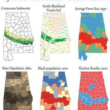
A line of blue counties stretches across the usually red-voting South which parallels curiously enough an ancient sea coast from 100 million years ago. Why?
Hale County in west central Alabama and Bamberg County in southern South Carolina are 450 miles apart. Both counties have a population of 16,000 of which around 60% are African American. The median households and per capita incomes are well below their respective state’s median, in Hale nearly $10,000 less. Both were named after confederate officers–Stephen Fowler Hale and Francis Marion Bamberg. And although Hale’s county seat is the self-proclaimed Catfish Capitol, pulling catfish out of the Edisto River in Bamberg County is a favorite past time. These two counties share another unique feature. Amidst a blanket of Republican red both Hale and Bamberg voted primarily Democratic in the 2000, 2004, and again in the 2008 presidential elections. Indeed, Hale and Bamberg belong to a belt of counties cutting through the deep south–Mississippi, Alabama, Georgia, South Carolina, and North Carolina–that have voted over 50% Democratic in recent presidential elections. Why? A 100 million year old coastline.
During the Cretaceous, 139-65 million years ago, shallow seas covered much of the southern United States. These tropical waters were productive–giving rise to tiny marine plankton with carbonate skeletons which overtime accumulated into massive chalk formations. The chalk, both alkaline and porous, lead to fertile and well-drained soils in a band, mirroring that ancient coastline and stretching across the now much drier South. This arc of rich and dark soils in Alabama has long been known as the Black Belt. But many, including Booker T. Washington, coopted the term to refer to the entire Southern band. Washington wrote in his 1901 autobiography, Up from Slavery, “The term was first used to designate a part of the country which was distinguished by the color of the soil. The part of the country possessing this thick, dark, and naturally rich soil…â€
Cretaceous rock units (139-65 million years old) are shown in shades of green. Older rock units are in gray, younger ones in yellow. From Geology and Election 2000.
Over time this rich soil produced an amazingly productive agricultural region, especially for cotton. In 1859 alone a harvest of over 4,000 cotton bales was not uncommon within the belt. And yet, just tens of miles north or south this harvest was rare. Of course this level of cotton production required extensive labor.
As Washington notes further in his autobiography, “The part of the country possessing this thick, dark, and naturally rich soil was, of course, the part of the South where the slaves were most profitable, and consequently they were taken there in the largest numbers. Later and especially since the war, the term seems to be used wholly in a political sense—that is, to designate the counties where the black people outnumber the white.â€
Readers can compare 2012 results using individual state maps at Politico.
A scientific swindler preyed on American scientists working in Geology during a period extending from 1884 to 1891, obtaining books, specimens, and money from a number of American scholars. He had a good knowledge of Eastern European languages, was well acquainted with the field and frequently assumed the names of prominent authorities. By the time he vanished from history, he had also accurately identified large numbers of specimens in American museum collections.
Newly arrived on the enemies list of the perennially concerned is California’s state rock, serpentine. A bill to oust serpentine is making its way through the California State Legislature, and geologists are flocking to the Magnesium Iron Silicate Hydroxide’s defense.
The bill to defrock the rock — which recently passed the full State Senate and is awaiting a vote in the Assembly — is sponsored by Senator Gloria Romero, a Los Angeles Democrat, with the strong support of the Asbestos Disease Awareness Organization.
Declaring that serpentine “has known health effects,†the bill would leave California — one of roughly half the states in the nation with an official rock or mineral — without an official rock. (According to the bill, California was the first state, in 1965, to name an official rock.) Asbestos occurs naturally in many minerals, and indeed some serpentine rocks do serve as a host for chrysotile, a form of asbestos. But geologists say chrysotile is less harmful than some other forms of asbestos, and would be a danger — like scores of other rocks — only if a person were to breathe its dust repeatedly.
“There is no way anyone is going to get bothered by casual exposure to that kind of rock,†said Malcolm Ross, a geologist who retired from the United States Geological Survey in 1995. “Unless they were breaking it up with a sledgehammer year after year.â€
Dr. Ross and other opponents of the bill are concerned that removing serpentine, which is occasionally used in jewelry, as the state’s rock would demonize it and thus inspire litigation against museums, property owners and other sites where the rocks sit; they cite the inclusion of a letter of support from the Consumer Attorneys of California with the bill as evidence.
“If they keep the asbestos issue bubbling,†Dr. Ross said, “it means money for politicians, more money for lawyers and money for scientists to investigate.â€
J. D. Preston, a spokesman from the consumer lawyers group, said the group had nothing to do with drafting the legislation and was just responding to a request from the awareness organization for a support letter. “We just thought this was a good fit in our mission of consumer safety,†Mr. Preston said. “It is certainly not the intent, and we don’t even see where it opens the avenue for litigation.â€
Gov. Arnold Schwarzenegger has indicated no position.
We were unable to interview Virginia’s state rock, as none has ever been appointed. Virginia’s state fossil Chesapecten jeffersonius, being naturally conservative, expressed mild chagrin at California’s radical politics, but was happy that California is so far away.
ScienceFair reads a new journal article in Nature Geoscience and begins to wonder.
Could the best climate models — the ones used to predict global warming — all be wrong?
Maybe so, says a new study published online today in the journal Nature Geoscience. The report found that only about half of the warming that occurred during a natural climate change 55 million years ago can be explained by excess carbon dioxide in the atmosphere. What caused the remainder of the warming is a mystery.
“In a nutshell, theoretical models cannot explain what we observe in the geological record,” says oceanographer Gerald Dickens, study co-author and professor of Earth Science at Rice University in Houston. “There appears to be something fundamentally wrong with the way temperature and carbon are linked in climate models.”
During the warming period, known as the “Palaeocene-Eocene thermal maximum†(PETM), for unknown reasons, the amount of carbon in Earth’s atmosphere rose rapidly. This makes the PETM one of the best ancient climate analogues for present-day Earth.
As the levels of carbon increased, global surface temperatures also rose dramatically during the PETM. Average temperatures worldwide rose by around 13 degrees in the relatively short geological span of about 10,000 years.
The conclusion, Dickens said, is that something other than carbon dioxide caused much of this ancient warming. “Some feedback loop or other processes that aren’t accounted for in these models — the same ones used by the Intergovernmental Panel on Climate Change for current best estimates of 21st century warming — caused a substantial portion of the warming that occurred during the PETM.”
The Palaeocene–Eocene Thermal Maximum (about 55 Myr ago) represents a possible analogue for the future and thus may provide insight into climate system sensitivity and feedbacks. The key feature of this event is the release of a large mass of 13C-depleted carbon into the carbon reservoirs at the Earth’s surface, although the source remains an open issue. Concurrently, global surface temperatures rose by 5–9 °C within a few thousand years. Here we use published palaeorecords of deep-sea carbonate dissolution, and stable carbon isotope composition, along with a carbon cycle model to constrain the initial carbon pulse to a magnitude of 3,000 Pg C or less, with an isotopic composition lighter than minus50permil. As a result, atmospheric carbon dioxide concentrations increased during the main event by less than about 70% compared with pre-event levels. At accepted values for the climate sensitivity to a doubling of the atmospheric CO2 concentration1, this rise in CO2 can explain only between 1 and 3.5 °C of the warming inferred from proxy records. We conclude that in addition to direct CO2 forcing, other processes and/or feedbacks that are hitherto unknown must have caused a substantial portion of the warming during the Palaeocene–Eocene Thermal Maximum. Once these processes have been identified, their potential effect on future climate change needs to be taken into account.